Utility Locating

Specialized Testing offers private utility locating services for the Los Angeles and surrounding counties. Our experienced technicians use state-of-the-art equipment to accurately identify and map underground utilities, ensuring the safety and efficiency of your construction or excavation projects. With a commitment to quality and customer satisfaction, Specialized Testing is the trusted partner for all your utility locating needs in Southern California.

Contact Us Or Call (562) 903-0032 Today!

Schedule Service

Service *

OUR Private Utility Locating SERVICE

PROFESSIONAL

Private Utility Locating

Using special radar scanning equipment and electro magnetic locating tools our team will reveal the exact location of underground utility cables, gas pipes, sewer lines, concealed rebars, tendons, metal and plastic conduits, glass-fiber cables at depths of up to 56″.

Our service will help minimize the chances of hitting concealed objects during construction or demolition.

Our Radar Scanning is also ideal for the inspection of floors, decks, slabs, balconies, concrete columns and other structures  such as tunnels, bridges and buildings.

electro magnetic utility locating
0

Utility Locating Projects

1 K

Satisfied Customers

Our Utility Mapping Service

PROFESSIONAL

utility mapping

We combine traditional utility locating methods with state-of-the-art geospatial tools to create detailed utility maps tailored to your needs. Our process includes real-time GPS data collection, 3D modeling, and high-resolution subsurface imaging to capture the precise location and depth of utilities. Whether you need a standalone utility map or integration with existing site plans, our experts deliver accurate, easy-to-interpret visuals that support efficient planning and risk reduction.
0

Utility Mapping Projects

1 K

Satisfied Customers

utility mapping showing locations on site
video pipe inspection service image

Our Video Pipe Inspection Service

PROFESSIONAL

CCTV VIDEO PIPE INSPECTION

At Specialized Utility Locating, we provide advanced video pipe inspection (also known as CCTV pipe inspection) to assess the condition of underground pipelines, sewer lines, and drainage systems. Using high-resolution cameras inserted directly into the pipes, we capture real-time footage to identify blockages, structural issues, or deterioration. This non-invasive method allows for precise diagnostics, reducing the need for costly excavation and guesswork.
0
VIDEO PIPE INSPECTIONS
1 K

Satisfied Customers

GPR Scanning

PROFESSIONAL ground penetrating radar scanning

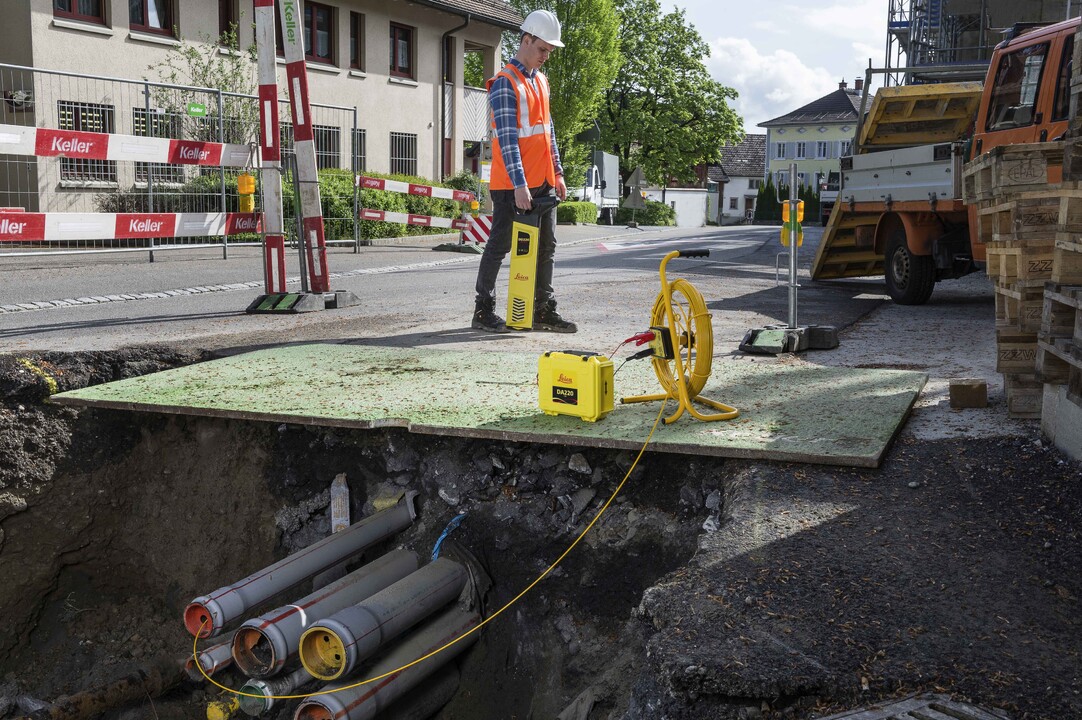
Specialized offers GPR scanning services in Los Angeles and Orange County, providing accurate detection of utilities, cables, and metal obstructions embedded within concrete slabs, walls, and other structures. With over 30 years of experience and thousands of successful GPR scans, we are a trusted leader in the industry. Specialized provides both standard and 3D GPR scanning options, utilizing advanced Ground Penetrating Radar (GPR) technology to help contractors, engineers, and property owners identify hidden elements before cutting, coring, or drilling. Our services minimize the risk of costly damage and project delays, ensuring safe and efficient project execution across commercial, industrial, and residential sites.
Concrete Scanning Icon
0

GPR Scans

1 K

Satisfied Customers

gpr scanning for utility lines in concrete service los angeles

WHAT IS Private Utility Locating?

utility locating underground private contractor

Private utility locating is the critical process of identifying and marking underground utilities that are located on private property. These utilities are typically owned and maintained by property owners or businesses rather than public utility companies. Private utility locating is essential for safe excavation, construction, or renovation projects on private land.

The Importance of Utility Locating

Types of utilities we scan

why is utility locating necessary?

Field Services

How does private utility locating work?

Private utility locating is done using specialized equipment, advanced techniques, and site analysis to detect and mark the locations of underground utilities on private property. Unlike public utility locating, which is often handled by “Call 811” services, private utility locating requires property owners to hire a professional locating company like Specialized Testing. Here’s a step-by-step explanation of how private utility locating is done:

Utility Locating process

Pre-Locating Preparation

Before using equipment, our utility locating technician will gather as much information as possible about your job site. This step helps guide our detection process.

Site Survey & Record Review

Review property blueprints, site plans, as-built drawings, and utility maps. Check for prior installation or maintenance records, as they may reveal where utilities are located. Interview property managers, owners, or contractors to gather information about known underground utilities.

Job Site Walkthrough:

Inspect the property to note potential indicators of underground utilities, like access points, valves, manholes, or visible risers.

Utility Detection Methods

Once we assess the site, our technician uses specialized equipment to detect and trace the location of underground utilities. Here are the most common methods and technologies we use:

Ground Penetrating Radar (GPR)

How it works: Sends high-frequency radio waves into the ground. When the waves hit an object (like a pipe or cable), they reflect back to a receiver, creating an image of what’s below the surface.
What it detects: Can identify a wide range of underground utilities, including non-metallic materials like plastic pipes, fiber optic cables, and voids. Best Use: Works well in areas with concrete, asphalt, or soil and can detect utilities made from plastic, clay, or other non-metallic materials.

Electromagnetic Locating (EML)

How it works: Uses an electromagnetic transmitter to send a signal through conductive materials, like metal pipes, rebar, or electric cables. A receiver detects the signal, helping locate the exact path of the utility. What it detects: Metal-based utilities such as copper, aluminum, or steel (pipes, electrical lines, telecommunications cables). Best Use: Most effective for locating conductive materials and is commonly used for locating power lines, gas lines, and telecommunications cables.

Inductive Locating

How it works: An electromagnetic signal is “induced” (injected) into a metallic utility line without direct connection. The signal then travels along the utility, and a receiver detects the signal at the surface.
What it detects: Metal pipes, cables, or wires. This method is useful when direct access to a utility line is not possible.
Best Use: When utility endpoints like valves or access points are unavailable, and when direct contact with the line is not possible.

Direct Connection Method (Active Line Tracing)

How it works: The technician connects a transmitter directly to the exposed utility line or a known endpoint. The transmitter sends a signal through the line, and the signal is detected at the surface by a receiver.
What it detects: Conductive utility lines (metal water pipes, electric power lines, gas lines, etc.).
Best Use: When endpoints are accessible (like utility boxes, control panels, or known entry points), making this the most accurate method.

Acoustic Detection

How it works: Uses sound waves or vibrations to detect hollow objects underground, like pipes. By tapping or introducing sound waves into the ground, echoes are used to identify subsurface objects.
What it detects: Water pipes, sewer lines, and other hollow pipes.
Best Use: Identifying leaks in pressurized pipes or finding buried pipes that are not easily detectable by electromagnetic or GPR methods.

Utility Marking

Once utilities are located, the technician physically marks their positions on the surface using color-coded markers, paint, or flags. Each utility type follows the American Public Works Association (APWA) Color Code system:

Utility Marking color coding

Red: Electric power lines, cables, and conduits.
Yellow: Gas, oil, steam, petroleum, or other hazardous materials.
Orange: Communications, alarm, and signal lines, cables, or conduits (like fiber optics).
Blue: Water lines.
Green: Sewer and drainage lines.
Purple: Reclaimed water, irrigation, and slurry lines.
Pink: Temporary survey markings.
White: Proposed excavation site (not for utilities, but for the work site itself).

These markings guide contractors, diggers, and heavy equipment operators to avoid utilities during excavation, drilling, or construction.

Documentation and Reporting

Once utilities are marked, the private utility locating company typically provides a report or site map showing the precise location, depth, and type of each utility. This report can be critical for project planning, excavation, and risk management.

Utility Mapping

Creates a digital map or hard copy diagram showing the exact location and depth of underground utilities.
Depth Analysis: Some advanced GPR systems can estimate how deep the utilities are below ground.
Digital Reports: Some companies use geographic information systems (GIS) or 3D mapping tools to create detailed utility maps.

Verification

After utilities are located, they may be verified through manual digging (also called “potholing” or “daylighting”). This process involves using hydro-vacuum excavation or air vacuum excavation to expose underground utilities without damaging them.
Hydro-Vacuum Excavation: Uses pressurized water to break up the soil and a vacuum to remove debris, allowing for safe, non-destructive digging.
Air-Vacuum Excavation: Uses pressurized air to break up soil, which is safer for delicate utilities like fiber optic cables. This process ensures that the markings are accurate and that any construction or excavation can be performed safely.
accent square

Our Certifications and accreditations

Why choose Specialized Testing for your Private Utility Locating?
We have the experience, Qualification and Expertise to handle your Next Project
ISO IEC 17025 Certified Laboratory
la dbs icon concrete testing icon
California certified disadvantaged business enterprise
California Division of General Services Architect Certified Concrete Testing Icon
IAS Accredited Materials Testing Laboratory Icon
Florida Department of Community Affairs Certified Testing Laboratory Icon
ccrl cement and concrete reference lab